
You are here
Sensor Networks
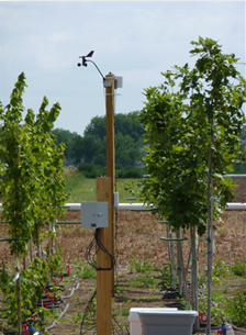 Anemometer measuring canopy windspeed at Willoway Nursery. The Decagon EM50R node logs and transmits data from the sensor network, whenever required.
In May of 2010, ten experimental macro-scale plots were established within a one hectare parcel at Willoway Nurseries.
Substrate volumetric water content and temperature was logged every five minutes (5TM sensors) in more than 5 containers per species using EM50R wireless nodes. From physical characteristics of the substrate, we can calculate the maximum and minimum soil moisture holding capacity, to estimate substrate volumetric water content.
Meteorological data (air temperature, precipitation, relative humidity, photosynthetic active radiation (PAR), and wind speed just above the canopy) were collected using atmospheric sensors logged by the wireless node (remote weather stations) located in the middle of each species experimental plot. Horizontal wind speed was collected along a canopy depth profile per species with a mobile tower of anemometers.
In addition, we geo-referenced every measured tree and atmospheric and/or substrate sensor in our study using a combination of GPS data and ground based surveying. Using this information we built maps of all of our atmospheric and soil sensor data collection locations.